


RS tardevent option 1

tgvpatrickfavre
User
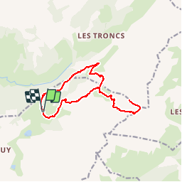

Length
15.3 km

Max alt
2491 m

Uphill gradient
1193 m
Km-Effort
31 km

Min alt
1316 m

Downhill gradient
1195 m
Boucle
Yes
Creation date :
2019-07-08 18:35:07.337
Updated on :
2019-07-10 18:46:48.977
6h11
Difficulty : Medium

FREE GPS app for hiking
 SityTrail
IGN / Geographical institutes
SityTrail Plus
The world is yours!
About
Trail Walking of 15.3 km to be discovered at Auvergne-Rhône-Alpes, Upper Savoy, La Clusaz. This trail is proposed by tgvpatrickfavre.
Positioning
Country:
France
Region :
Auvergne-Rhône-Alpes
Department/Province :
Upper Savoy
Municipality :
La Clusaz
Location:
Unknown
Start:(Dec)
Start:(UTM)
304887 ; 5088618 (32T) N.
Comments